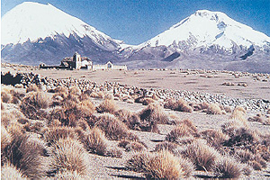
We can distinguish five of the great basic forms of the Chilean relief.
This are: coastal or littoral plains, Coastal ranges, intermediate depression, high plateaus and the Andes Ranges. However, in the coastal zone and the intermediate depression there are two new geographical accidents: the coastal cliff and the Tarapaca Meseta
– Coastal or littoral plains: they are scarce and almost nonexistent in this region. It is present in a very narrow way (no more than 2km wide), except where is the Arica city.
– Coastal cliff: is a uniform mountain chain divided by the Vitor creek (southwards Arica). This formation falls abruptly on the sea in the form of a bluff.
– Coastal Ranges: is born in the Camaraca Hill, 30km south of the Concord line. Does an isolated nucleus possess the character of isolated mounds reaching above the 1.000 masl. This morphology is equal in the whole coastal sector in between Arica, on the North and the Camarones pampa, by the south.
– Intermediate depression: is an extended plain reaching 40 km wide and which heights from the 500 to the 2.000 masl. Their principal pampas are Chaca and Camarones.
– The Tarapaca Plateau: is located and interrupted by several creeks which have originated small pampas such as Chaca and camarones.
– High Plateau: is a high plateau of great extension located at great height (4.000 masl). Is in the western zone of the Andean sector. Here we can find several rivers and lagoons, which waters do not reach the sea., such as; Caquena, Lauca, Isluga and Cariquima rivers, the Chungara lake and the Parinacota, Cotaconi and Blanca lagoons.
– The Andes Ranges: presents herself massif, high and volcanic, with altitudes reaching above the 6.000 masl. Some of the most important are the Parinacota (6.342masl) and the Pomerape (6.282 masl), which, jointly, forms the Payachatas Snows, in the frontier with Bolivia Also, there are the Guallatiri (6.060 masl) and Tacora volcanos (5.980masl).


