In this chapter, we have gone over the main geographical aspects (physical, human, economic etc.) of the region of Antofagasta.
Territorial organization and physical geography
– The capitol of the region is Antofagasta, and administratively, it is split into threee provinces: Tocopilla, El Loa and Antofagasta.
– This region’s relief has five characteristic zones, and they are: the coast and coastal plains, the Coastal mountain range, the intermediate depression, the Andes mountains and the high plateau.
Economic and human geography
– The region’s main economic activity is mining and copper is the most important product. In fact, in 2007, this region comprised 56.7% of the country’s national copper production and it exported 61.1% of the country total.
– A few of the main copper deposits in this region are Escondida, Chuquicamata, Radomiro Tomic, El Abra, Spence, Gabriela Mistral, Zaldivar, El Tesoro, Michilla, etc.
– According to numbers from the 2002 Census, the regional population is 492,984 inhabitants, and the fastest growing comunas (counties) are San Pedro de Atacama, Sierra Gorda, Mejillones and Antofagasta.
Tourist geography
– A few of Antofagasta’s tourist attractions are La Portada (The Gateway), the Huanchaca ruins), Coloso Cove and its beaches.
– There are some very interesting places between Taltal and Antofagasta, such as the Paposo Reserve, El Medano gully and Paranal Astronomical observatory.
– San Pedro de Atacama, located 2,450 masl, at the far north end of the Atacama saltpan, has become one of Chile’s great tourist attractions.
“Circulation authorized by Resolution Nº190, from June 12th, 2008 by the National Administration of State Borders and Limits. The editing and circulation of the maps referring or relating to Chile’s borders and limits do not make any kind of commitment on the part of the State of Chile, in accordance to Art 2, letter g) of Decree Law Nº83 from 1979 of the Ministry of Foreign Relations”.


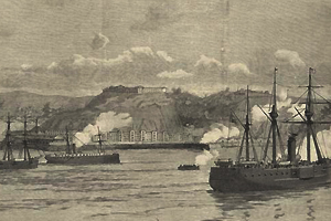
 En 1866 Valparaíso fue bombardeado