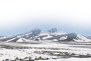
In this region, we can distinguish four of the basic relief forms. These are: littoral plains, Coast ranges, transversal valleys and the Andes Ranges. Nevertheless, in this zone the relief adopts particular forms and there are great heights. Among this relief differences, stands out the appearance of the transversal valleys.
– Littoral plain: is very narrow and has a brief development since is interrupted by foothills fallen off the pampas into the sea. It reaches an extension fluctuating between the four and eight kilometres. It becomes bigger in the Copiapo (40km) and Huasco rivers (35 km) and in the Totoral village (40 km)
– Coastal Ranges: is interrupted by the transversal valleys and its height diminish notoriously. Thus, for example, from the Salado creek until the Copiapo river, there are heights inferior to 1,500masl. The only important group of mountains is in Sierra Gloria, located northbound the Copiapo city.
–Transversal valleys: these are replacing the intermediate depression and have water courses allowing the development of agricultural activities.
There are two important valleys:
-
Undulated or southern pampa: stretching by the north, among the Vicuña Mackenna, the Hombre Muerto and the Peñafiel mountain ranges (all of them in the Region of Antofagasta) until the Copiapo river, by the south, reaching a 230 km southbound and 70 km westbound, narrowing among the littoral plains. The Aspera and the Gloria are the most important mountain ranges interrupting this pampa.
-
Transitional pampa: stretches in between the Copiapo and Elqui rivers (Region of Coquimbo), reaching southbound a 55 km width. Located in a zone where the erosive effects of the landscape are notorious and where the arid plain narrows in a net of isolated hills and creeks. Among these stand out Los Cristales, Oronqui and the Romero small mountain range.
– The Andes Ranges: it has different characteristics:
-
Sloped Plains: They are between the 1.500 and 3.000 masl having a, approximately width of 35 km and a length of 105 km.
-
Andean foothills: strongly affected by erosion with an extension of 110 km southbound. It has numerous high peaks, such as the Bolson (4.868 masl), the Infieles (5.012masl) and Doña Ines (5.073 masl). These latter ones surround partially the northern part of the Pedernales saltpan. Southwards this saltpan, the Domeyko Andean foothill restarts through the Bravo Alto (5.315masl), Codocedo (4.623 masl), Blanco (4.390 masl), la Ola (4.244 masl) and the Toro (4.094 masl) hills.
-
Andean mountain ranges: they stretch northwards from a series of elevations comprising the Pujsa saltpan up to the Ojos del Salado, by the south. These mountain ranges are typical for their great heights, above the 6.000masl. For example, the snow capped Ojos del Salado (6.983masl), the snow capped Tres Cruces (6.753 masl) and the Colorado hill (6.080 masl). Also, they have many salty basins.
-
Range-Transversal mountain ranges: this stretches from the Ojos del Salado southbound (going beyond the regional boundary) with a 90km width.


